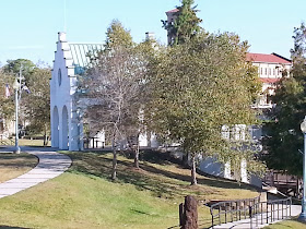
 Last weekend we attended the Fiber Arts Festival in Plaquemine, LA, and discovered a state park!
 While we spent the majority of our time at the festival, we could not resist going to the Lock Museum to find out what we could learn. Turns out there's lots to learn about how Louisiana (and other places) controls the water and makes shipping more efficient.
 |
A couple of map cabinets, which apparently visitors can access. (That hand below is Richard's.)
An interesting replica of the town with the lock and dam. Check out the locks part of the model...looks pretty real and makes seeing the entire works quite easy. The park ranger is very good at explaining how the locks work.
Smaller ships would run through this canal to Plaquemines Bayou which eventually runs into the Intercoastal Waterway and the Gulf of Mississippi. If you note the hairpin curves in the Mississippi River, you can imagine how much time and fuel boats can save.
One of the many maps that are available. This one shows the section of the Mississippi River close to where we are. Note the curves in blue--that's the Mississippi's fuel sucking route.
These photos are of the outside of the Lock building. Note the interesting architectural details.
The photo below is of one of the pavilions in the city park. I realized that it has a few copied details from the Lock House: the unusual stair-step roof line and the rounded doorways.
If you ever get an opportunity to visit Plaquemine, you should definitely visit this state park. You'll see lots of interesting antiques, learn about how water is controlled, and see a different perspective of the Mississippi River.


Hi there, There's no doubt that your site may be having web browser compatibility issues.
ReplyDeleteWhen I take a look at your web site in Safari, it looks fine however, if opening in I.E., it's got
some overlapping issues. I merely wanted to provide you with
a quick heads up! Apart from that, wonderful blog!